WATER LEVELS
DAVE BAKER
Many of us were concerned about the abnormally low water level on Long, Mickey and Ruth lakes last fall. We had trouble navigating through shallower channels, water levels beside our docks were not sufficient, and stretches of newly exposed beach appeared in areas that were previously below water. People wondered about the cause of the lower water level. While some people blamed the exit through Sucker Creek (part of the Platte River watershed) for draining water from Long Lake too aggressively. Others noted the lack of ice cover from the unusually warm winter during the prior year. What was really going on?
Drainage through Sucker Creek was not a material contributor to the lower water level. The area between the creek bed and the culvert under West Long Lake Rd. was dry during the late summer and early fall. Even though the water level was too low to reach the culvert, lake levels continued to decline.
The Long Lake watershed is an area surrounded by glacial deposits left from the last ice age. Partly due to the composition and placement of these glacial deposits, there are no streams or rivers feeding Long Lake. Groundwater feeds the Long Lake watershed. When groundwater is higher, our lake level rises, and the lake level falls when groundwater recedes. Other factors, including light winter snowfall, increased evaporation due to lack of winter ice cover, and below average rainfall in spring and summer contributed to the reduced water levels in our lakes during 2024.
The following graph shows data from the water level tracking buoy on Long Lake between 2012 and 2024.
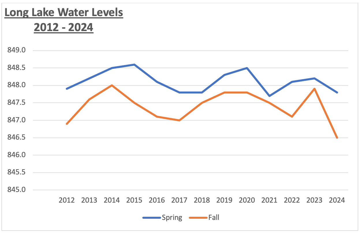
The prior graph shows notable elements:
- Water levels always begin higher in the spring and end the year lower.
- The difference between the spring high and the fall low is about one foot of decline.
- Water levels follow a pattern of cyclical peaks and lows.
- The water level decline in 2024 was more pronounced than prior years and resulted in the lowest water level in the last 13 years. Lake levels last fall were six inches below the lows recorded in the fall of 2012, 2016, 2017 and 2022.
In summary, while levels of rainfall, evaporation and waterflow exiting from Long Lake into the Platte River watershed can impact the water level in our lakes, the primary influence is the level of the groundwater in the area. While there is not much that we can do to influence the groundwater level, we can take note of the cyclical pattern of the high/low water levels over time and expect a return to higher levels in the future.